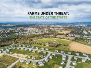
American Farmland Trust’s new report used spatial mapping analyses of agricultural land conversion to provide unprecedented insights into the status and fate of American farmland. Our findings and maps of agricultural land at the state, county, and even sub-county levels show that between 2001 and 2016, 11 million acres of farmland and ranchland were converted to urban and highly developed land use (4.1 million acres) or low-density residential land use (nearly 7 million acres). The report also shows how states have—or have not—responded to the threats of agricultural land conversion. Our Agricultural Land Protection Scorecard assessed six policy tools commonly used to protect farmland, support agricultural viability, and provide access to land.
To explore our maps, policy scorecard, and background data use the links below to visit our interactive website. To view AFT’s Farms Under Threat raster data and create your own map with your selected layers and edits, use the American Farmland Trust Raster Atlas. The Atlas includes Farms Under Threat data layers from Farms Under Threat: State of the States, Farms Under Threat 2040, and Wildlife Connectivity Across U.S. Agricultural Lands.


